Bangalore about to face prolonged rainfall and storm
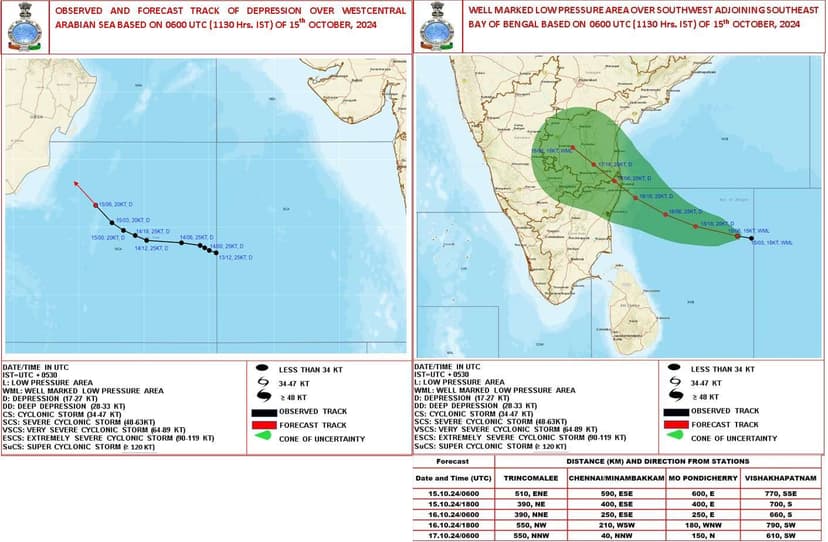
A well-marked low pressure area currently centered over the southwest and adjoining southeast Bay of Bengal poses a direct threat to Bangalore in the coming days. As of 1130 hours IST on October 15, 2024, meteorological data indicates a high probability of this system affecting our city. Here's what you need to know:
-
System Intensification: The low pressure area is expected to intensify into a depression within the next 12 hours. This rapid development warrants close attention as it will likely influence the system's impact on inland areas, including Bangalore.
-
Projected Path: The forecast track, clearly visible in the right-hand map, shows a west-northwestward movement. Critically, Bangalore falls within the green-shaded "cone of uncertainty," indicating a significant probability of direct impact.
-
Timing: The system is projected to reach the coasts of north Tamil Nadu, Puducherry, and adjoining south Andhra Pradesh by early morning of October 17th. Given Bangalore's geographic position relative to these areas, we can expect to feel the system's effects potentially starting late on October 16th, with peak impact likely on October 17th.
-
Potential Impacts:
Precipitation: Expect substantial rainfall, potentially leading to urban flooding given Bangalore's topography and infrastructure.
Wind: Increased wind speeds may affect city operations and outdoor activities.
Temperature: A likely drop in daytime temperatures due to increased cloud cover and precipitation.
-
Urban Considerations: Bangalore's urban heat island effect and extensive paved surfaces may exacerbate flooding risks. The city's stormwater drainage system will be put to the test.
-
Broader Context: While the Arabian Sea depression mentioned is moving away from the Indian subcontinent, its presence may indirectly influence overall atmospheric conditions, potentially intensifying the Bay of Bengal system's effects.
-
Uncertainty Factors: The "cone of uncertainty" in the image underscores the inherent variability in weather system predictions. Residents should prepare for a range of scenarios within this cone.

One interview, 1000+ job opportunities
Take a 10-min AI interview to qualify for numerous real jobs auto-matched to your profile 🔑
Ah damn!!